
| |
| The large town of Scunthorpe, Lincolnshire is located on a ridge 8 miles south of the River Humber, and 4 miles east of the River Trent. The station is near the centre of the town, and is at an altitude of 39 m above sea level. |
|
|
The core of this automatic weather station consists of a Raspberry Pi computer.
This runs programs in the Python language which reads various sensors and instruments.
The computer then processes and stores this information, and produces web pages to display it.
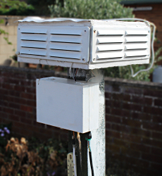
The electrics are located in a water-proof box. The main sensor is located in
the Stephenson Screen. Cables go to the rain and wind measuring instruments. Everything is powered by a 12v solar panel. |
|
|
Temperature, humidity and air pressure are measured using a BMP280 sensor. Grass and Soil temperatures are measured using a DS18B20 Temperature Sensors The grass sensor is located 1 cm above the ground on top of grass. The soil sensor is 30cm below the top of the soil. Ultra-Violet is measured using a VEML6075 UVA/B Sensor Rainfall and windspeed are measured using simple digital switches on measuring devices. Wind direction is measured using a RasPIO analog zero interface which returns different electrical resistance values depending on the position of the wind vane. Wind vane and anemometer are located 5 metres above ground level. Snowfall and depth are input manually. |
|
|
The 'All Sky Camera' uses a second Raspberry Pi and a PiCamera with a Fisheye 222° Lens.
|
|
|
From 2014, weather data was being recorded using the now defunct Maplin weather station, and by using Cumulus software. On 18th January 2019 the present
weather station began operation.
|
|
|
Data from this station is uploaded to the UK Met Office 'WOW' website every 10 minutes. |
|
 |
 |
 |
 |
 |
 |